Getting there: From south MoPac, take the Loop 360 exit
and head west. Turn left at the light at the intersection of 360 and
Scottish Woods Trail. The road on the other side of 360 from Scottish Woods Trail
is called Westlake High? Drive down Scottish Woods Trail until you get to a 'T'
section in the road. Park along the road on Scottish Woods Trail because the other
roads in the are much narrower. The entrance to the Barton Creek Greenbelt is just
to the right of the 'T' intersection of Scottish Woods Trail and Camp Craft Road.
Please be advised that this area is a residence with no marked parking. So
please be on your best behavior here. Don't block the resident's driveways or
mail boxes. If you're starting your hike early in the morning keep the noise
down so as not to wake anyone. Be respectful of the folks who live here and
get to the trail and back to your car quickly.
The Hike: The start of the hike, marked "Trailhead", is at the
top of a hill over Barton Creek. The first quarter mile is a steep drop of about
250 feet to the creek bed. This section of the hike will make your legs burn when
you have to walk up it after 6+ miles of hiking. Right before you get down to
creek level there is a restroom located near the waypoint marked, "Fork". Here
you'll also see a fork in the trail with some options to go further upstream,
which we'll explore later.
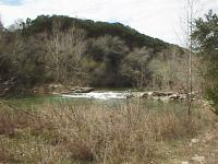
Scottish Trail Falls
The first thing you'll encounter when getting to Barton Creek is a nice water
fall with a picnic table perched on a large boulder, very close to the flowing
water. This spot is marked with the waypoint "Falls". You'll see several falls
along the trail, but this one is one of the nicer falls until you get to
Sculpture Falls later on the trip.
The trail near the waypoint marked "Rock Falls" passes near a large rock face
to the left of the trail. This rock is relatively weak and prone to breakup. Don't
worry, rock slides are not going to happen. But what has happened is that a
large number of boulders have broken off of the rock face and come to rest at the
trail level. Some of the boulders are huge. Some other areas are made up of
large quantities of smaller rocks piled up along the slope. None of these rock
falls obscures the path of the trail.
"Slanted Falls" is a small waterfall that is angled about 45 degrees off of the
flow of Barton Creek. Several other falls dot the area, too many to bother marking
on the map.
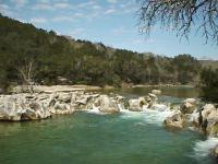
Sculpture Falls
The highlight of the trip is Sculpture Falls, marked by a waypoint of the same
name. This is probably the loudest water fall on the Barton Creek Greenbelt. The water
has carved very interesting patterns in the rock as you may be able to see in the
photo. Better yet, see for yourself. A deeper spot on the downstream side of the
falls makes for a good swimming spot.
There are no springs readily apparent on this side of the creek, though
when you get to the waypoint marked "Springs" you should be able to see the
twin springs flowing from the rock on opposite bank.
Glade
One of the more pleasant sections of all of Barton Creek can be found around the
waypoint marked "Glade". At this point a rocky streambed crosses the trail, but on
either side of the creek the terrain is relatively flat and completely covered in
trees. The trees make the area a little cooler and also help to filter out noise,
adding to the tranquil setting.
The waypoint marked "Twin Falls" is the location in which the established trail
crosses Barton Creek and continues on the other shore. Twin Falls is a very popular
resting place and can get crowded, particularly when the weather is good. If you
prefer more solitude we recommend Sculpture Falls or Scottish Trail falls further
upstream.
The waypoint marked "Trail Access" is the official end of the supported trail.
At this point the official trail heads up hill to the Cairnes access point.
However, a well defined, but noticably smaller and less used trail continues
downstream. Of course, we elected to take that route.
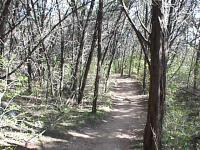
Greenery abounds
The trail here is more challenging than the supported trail. At one point, a
rock fall completely covered the trail and partially obscured the trail continuation
on the other side. Be careful crossing at the point marked "Rock Fall". Many of
the rocks are loose.
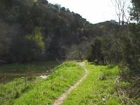
You won't run into many people along this portion of the trail. Mostly you
may see and hear hikers and bikers on the other side of Barton Creek as they
travel along the South Upper Barton Creek trail.
We turned around at the waypoint marked "Turn Around", though the trail continued
onward and probably rejoins the established trail when it crosses Barton Creek
at Gus Fruh Park.