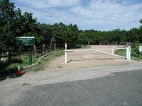
Stillhouse Hollow Nature Preserve

Trail
0.60 Mile
75 Feet
N/A
2point5stars (2.77)14
1star (1.04)
3point5stars (3.64)
N/A
No
No
No
Austin
Travis
More Info

Despite conflicting information on city maps and a closed parking area, this trailhead is open for visitors. However, the sign now says 'Stillhouse Hollow' and not 'Spicewood Springs'!
Getting there: From central Austin, head north on MoPac and take the Anderson Lane/Spicewood Springs exit. Turn left and head west on Spicewood Springs to Mesa Drive. Turn left on Mesa and head south to Burney Drive then turn right. Head west on Burney Drive and park along the street near the intersection with Rustling Road. The preserve entrance is on the north side of Burney, slightly to the east of Rustling Road.

The Hike: Is someone trying to keep us away from this hike? It seems that way, considering all of the difficulty we had in locating it. First, our street map shows a park by the name of Stillhouse Hollow Park near this location where a row of houses resides. The official City of Austin Parks and Recreation Department parks map at the time showed a Stillhouse Hollow park here where there was none. Since our initial visit to this preserve the Spicewood Springs sign has been replaced by a Stillhouse Hollow sign and hopefully we can finally put to rest that name for this hike!

The start of the trail has some open spaces, but that soon ends.
On the last street that we investigated we spotted the entrance to the preserve, but the gate was closed. According to the sign at the entrance the preserve was open, but the gate leading to a small parking are was locked. Unwilling to be turned away we parked the car along Burney Drive and ventured forth to see what was someone was apparently trying to hide from us.

The trail begins at the waypoint "Trailhead", situated next to the locked gate which prevents visitors from parking in the half dozen spaces constructed for the park/preserve. The trail follows the paved path to left. The entire length of the trail is paved, which makes for an easy stroll for hikers of all abilities.

The preserve trail is mostly covered by a thick canopy of Cedar.
The preserve features thick stands of Mountain Juniper that provide ample shade from the Sun. Parts of the hike are almost dark in comparison to the glare one might encounter in the one open area of the trail near the parking spaces. In general the trail gently slopes downward on the way out, as it approaches the edge of a steep creek valley.

The trail surface is paved throughout, making the hike easy for all.
All through our hike we expected the trail to end at any moment. We were pleasantly surprised when the path was extended again and again through turns in the Cedars. Eventually the trail did end. But a surprise awaited us in the form of an impressive wooden deck that overlooks the steep drop into the canyon of a creek that eventually feeds into Bull Creek. On the day of our visit there was a pleasant cool breeze shooting through the valley and the deck provided a wonderful place to stop for a rest.
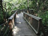
At the end of the trail is this surprising observation deck that sits on the edge of a steep drop into the canyon.

The trail doubles back on itself back uphill towards the trailhead. In all, this small preserve provided over half a mile of surprisingly secluded hiking within a stone's throw of the many homes that surround it. We hiked the trail in about xx minutes, but wished we had spent some more time sitting at the deck overlooking the canyon.

Austin features another nearby component to the Balcones Canyonland System in Barrow Preserve. That land sits but a few blocks to the west of this trail. Thus far we have not found any trails in Barrow Preserve nor any connecting trail between the Stillhouse Hollow and Barrow preserves.

Photos
overhang
this was at the end of the trail (Photo by jimmy peace)
Background & rules
Background & rules (Photo by plectrudis)
Characteristic view of winding trail
Characteristic view of winding trail - Mix of oaks, elms, and juniper, with a fair bit of twist-leaf yucca (Photo by plectrudis)
Map
Map - though, seriously, you'd have to make a concerted effort to get lost--there's only the one trail, and it's paved. (Photo by plectrudis)
7810 Sterling
Main entrance. There's also a little cut-through for residents of the adjacent apt complex. (Photo by plectrudis)
Twisted junipers
Stillhouse Hollow is full of junipers with craggy trunks, covered in lichen and moss. (Photo by kittythedog)
Log Entries
another secluded preserve
By jimmy peace on 5/27/2019
Rating: 3point5stars Difficulty: 1star Solitude: 4point5stars
Distance: 1.00 Mile Duration: 1 hour

discovered a nice overhang at the end

Short, paved stroll in the woods
By plectrudis on 1/7/2018
Rating: 3stars Difficulty: 1star Solitude: 2point5stars
Distance: 1.00 Mile Duration: N/A
This trail was hard to find, as Google tries to convince you to enter through a gated apartment complex. In fact, you need to turn into the subdivision around the corner from the apartments to find the entrance--take Mesa to Burney to the tiny dead-end street of Sterling and there it is. But I'm glad I dead, as a short little excursion in pleasant surroundings was just what I was looking for. The whole trail is paved, though the pavement has become a bit wavy with age, so it might not be 100% accessible for the especially frail. The path winds though a small wood and eventually reaches a nice observation deck overlooking a little ravine. I thought the overlook was a bit of an anti-climax--you can't see much due to the density of trees, even in the winter. But for a nice, quick saunter, it's a good choice if you're in the area. Note that dogs are not allowed, as it's not just a park but a nature preserve.
Fire burned observation deck.
By djfisher on 9/29/2014
Rating: 3stars Difficulty: 1star Solitude: 4stars
Distance: 1.00 Mile Duration: N/A

http://tweetymail.com/users/AustinFireInfo/posts/2014/09/01/02-03-31

A fire burned the observation deck. I hope it gets repaired, probably not.

Lovely, short stroll
By jtkatie on 9/5/2010
Rating: 2point5stars Difficulty: 1star Solitude: 2point5stars
Distance: 1.50 Miles Duration: 30 minutes

As we knew that this trail was short, we planned to walk it at least twice. It took us about 12 minutes round-trip (from gate to deck) the first time.

On our second time down, we happily watched a little rabbit off to the side of the path. While we watched it eat, we had two other couples pass us - which surprised us, as we figured hardly anyone knew about this path.

We were a bit disappointed with the "observation deck" as we could not do much "observing" with the trees grown up so much! We wouldn't want them to be trimmed... but there is probably much more to see if you visit in the fall / winter.

The path is well-paved throughout, but we wouldn't say that the trail is accessible for wheelchairs (without quite a bit of help during the steepest parts).

Nice walk, very short
By rpmcgill on 6/18/2010
Rating: 2stars Difficulty: 1star Solitude: 3stars
Distance: 1.00 Mile Duration: N/A
This was a nice trail, more of a stroll than a hike, really. We saw no other people on the trail, but we did see a deer lounging in the shade and a few prairie runners.
Very nice, short hike to a canyon overlook
By HikingJo on 4/22/2010
Rating: 4stars Difficulty: 1star Solitude: 4stars
Distance: 0.60 Mile Duration: 30 minutes
The habitat along this trail should contain golden-cheeked warblers, an endangered, beautiful species unique to the Texas Hill Country around Austin -- oaks on the canyon walls, plus lots of junipers on the flat section. The warblers use the shaggy bark of mature junipers to build their nests. The end of the trail with the canyon overlook is lovely and quiet, with water trickling far below, woodpeckers and jays calling overhead. Today we also heard migrating waterfowl calling to each other high overhead, but it was too cloudy to see what they were. I plan to go back some morning early and look and listen for warblers. Today we were there mid afternoon, a terrible time to bird-watch!
Trees!
By texaskdog on 3/25/2010
Rating: 2stars Difficulty: 1star Solitude: 4stars
Distance: 1.00 Mile Duration: 20 minutes

Nice for what it is just short.  Really not hard to find.

quiet monday afternoon
By barefoot mcgraw on 9/7/2009
Rating: 3stars Difficulty: 1star Solitude: 5stars
Distance: 1.20 Miles Duration: N/A

worn pacement is rough
for tender newly-barefoot
yet it's worth the walk

to behold the end
and rest before returning
passing little deer

short, easy stroll through the woods
By tnash on 5/9/2008
Rating: 2stars Difficulty: 1star Solitude: 2stars
Distance: 1.00 Mile Duration: 35 minutes
Nice little trail
By kittythedog on 3/11/2008
Rating: 3stars Difficulty: 1star Solitude: 4stars
Distance: 1.20 Miles Duration: 1 hour, 30 minutes

Once the rain stopped yesterday I had to get out of the house but I didn't want to go too far and end up in a traffic jam.  So I headed west to this little spot for some birdwatching and photography.  The beginning of the trail cut through Ashe juniper monoculture, but the canyon at the end of the trail is one of those gorgeous hill country canyons with maidenhair fern and sycamores.  I only saw two other people on the property, one being a neighboring resident letting her dog roam free (tsk tsk!).  It's a nice place for an afternoon walk. 

Only showing last 10 log entries. View All Log Entries

Recommended Item
Recommended Item 60 Hikes Within 60 Miles: San Antonio and Austin: Including the Hill Country
Charlie Llewellin, Johnny Molloy
List Price: $18.95 Your price: $12.90 Buy Now
It's Time to Take a Hike in San Antonio!

The San Antonio and Austin areas are steeped in history -- San Antonio's Alamo stands as a symbol of Texas' fierce independence, while Austin is recognized as the cradle of Texas statehood. This area is also known for some of the most impressive hiking in the Lone Star State. 60 Hikes Within 60 Miles: San Antonio and Austin, by veteran authors Charlie Llewellin and Johnny Molloy, guides readers to the best trails found in the Texas Hill Country, all within easy reach of these two cities. The guide takes you to secluded, low traffic areas as well as those that are more popular and heavily used. The former LBJ Ranch, the Guadalupe River, the Highland Lakes Chain, and the Lost Pines area are just some of the spectacular places covered.

With this new edition in the best-selling 60 Hikes Within 60 Miles series, all these visually stunning and ruggedly charming routes are at the traveler's fingertips. This handy guide helps San Antonio and Austin natives get back into nature, with many options right in town. Extensive at-a-glance information makes it easy to choose the perfect hike based on length, difficulty, scenery, or on a specific factor such as hikes good for families, runners, or birding. Each trail profile includes maps, directions, driving times, nearby attractions, and other pertinent details.