Getting there: From MoPac in Austin, head west on FM 2244. Continue
west on FM 2244 through the intersection with Capital of Texas Highway. Aproximately
3.5 miles after that intersection turn right on Cuernavaca Drive and then turn left
on Commons Ford Road. Continue down this road for and look for the entrace to the park
on the left. Parking is along the shoulder of the road. Look for a brown wind gauge and
antenna on the left for an indication of where to park.
-small.jpg)
Much of the trail is heavily wooded with Junipers, Oaks and other trees.
Commons Ford Park was something of a mystery when we first
found out about it. We had hopes of miles of trails and few people to disturb a peaceful
hike. In some ways the park and the Waterfall Trail did not live up to those expectations. However, we found that we enjoyed the trail immensely.
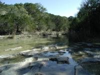
This small creek is carving the Commons Ford valley and providing some pleasant waterfalls. We're happy to report that the water appeared to be very clear.
This hike follows a creek up stream where it emerges from the hills and empties into Lake
Austin. At only a mile round trip it packs a lot of sights and sounds in a short trip.
The trail begins at the waypoint "Trailhead". Like other Commons Ford trails parking here is anywhere along the shoulder of the road. Follow the well worn dirt path south for a short distance and it will suddenly become rocky and covered with trees and plants.
The trail for much of its length is rocky though for the most part not terribly rough.
There are a couple of stream crossings, none of which posed a problem as the stepping stones put in place by others were more than adequite to get across the trickling waters.
-small.jpg)
Did we mention that the trail is heavily wooded? Note that there were a lot of broken branches along the trail.
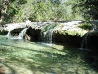
A more significant flow of water became evident near the waypoint "Waterfall 1". The sound of flowing water can be heard well before it is seen. The waterfall here is not very large but it does produce a nice soothing sound. The creek runs into a slab of igneous rock here which it flows over. The rock surface has been carved by the water to resemble the curves and pitholes reminiscent of Sculpture Falls along Barton Creek.
The remnants of a fence line can be seen here as it crosses the creek and continues up the
slope on the opposite bank. This line does not mark the park boundary and so must be a
relict of the property's ranching past.
The trails pulls away from the creek slightly as it continues south. As it does so it also gains altitude. There is little strenuous vertical gain. The change is altitude is mostly felt by the views of the steeper slope beneath the trail. Although some spots along the trail are a little narrow, the danger of falling down the hillside is remote. The trail is well positioned along the slope of the hill overall.
-small.jpg)
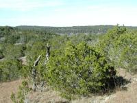
Occassionally the trail breaks into an opening, providing for some views of the hills.
The waypoint "EF" marks the location of the Enchanted Forest geocache. There was not enough room on the map for the full name to be printed. This tough one is located on a ridge looming over the Waterfall Trail. We won't give away too much but plan your route up to the cache location carefully as the choice you make can determine how tough the ascent to the cache is.
By the time you near the area of the Enchanted Forest cache you'll have heard the call of
the trail's biggest draw - it's main waterfall. Of course if you hike during a particularly dry spell this may not be the case. During our December trip the falls did not disappoint.
This pleasant multi-waterfall appears to be the end of the trail, but not entirely.
The falls at the "Waterfall 2" waypoint are taller than it's downstream companion so it produces a richer sound. Like the waterfall encountered earlier the water runs into a large slab of rock that withstands weathering better than the looser rock around it. At this point it looked like the end of the trail and really it was, though we found a way to extend the trip and find some great valley views. Turn around here for a shorter hike.
If you'd like to see more of the park look to the right of waterfalls rock slab. There is
a way to climb up on top of the falls. From here a short path leads to water before it falls over the rock ledge. Here one can observe more rock patterns carved by the relentless flow of water.
By hiking along the clearings on the opposite bank one can catch glimpses down the creek valley and cliffs on the far lake shore.
On top of the ledge there appears to be a continuation of the trail on the opposite bank.
By using the highpoints of the rocks carved surface it's possible to get across the stream
without getting your feet wet. The trail continuation scrambles up a short but steep slope and then quickly disappears. However, the foliage here turns slightly less dense. The juniper is more spaced out with grasses in between. This provides plenty of room to continue straight up the slope of the hill. In some places there appears to be evidence of a fire having raged through this section of the hill some time in the past, which would explain the sparse sprinkling of the highly flammable junipers.
As we hiked up the hill the sparse tree coverage provided great views down the creek valley back towards Lake Austin. In some cases we could see the cliffs on the opposite shore of the lake. These great views made the extra effort to get to this point worthwhile. As you continue up the hill the tree coverage grows more dense and eventually the prospect of squeezing between junipers branches outweighs the curiosity of what's further up hill. As it turns out that's just as well since the trail was nearing, but not yet leaving the boundary of the park at the waypoint "Turnaround". At this point we headed back down the hill and back to the trailhead.
The geocache that was placed in this park provides a way of describing the environment.
In many ways it does appear to be an Enchanted Forest. The hour and a half that we spent
hiking the trail was enchanting indeed.